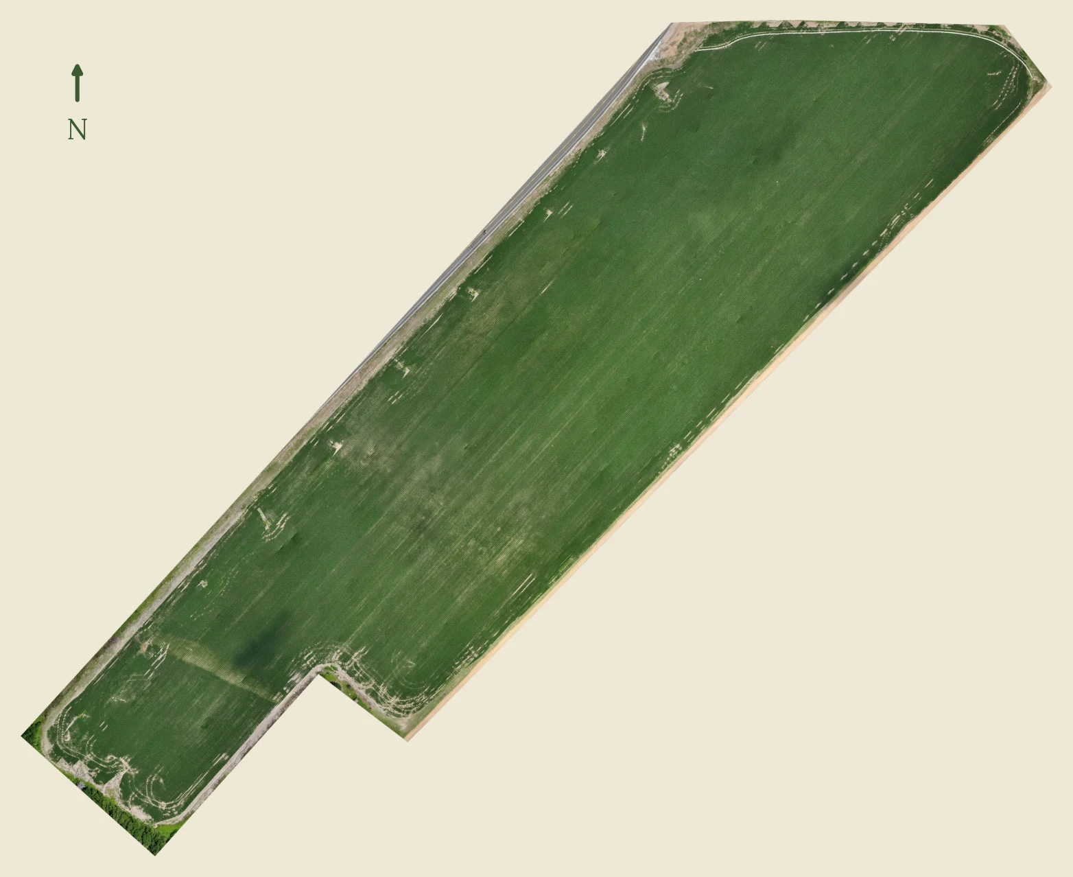
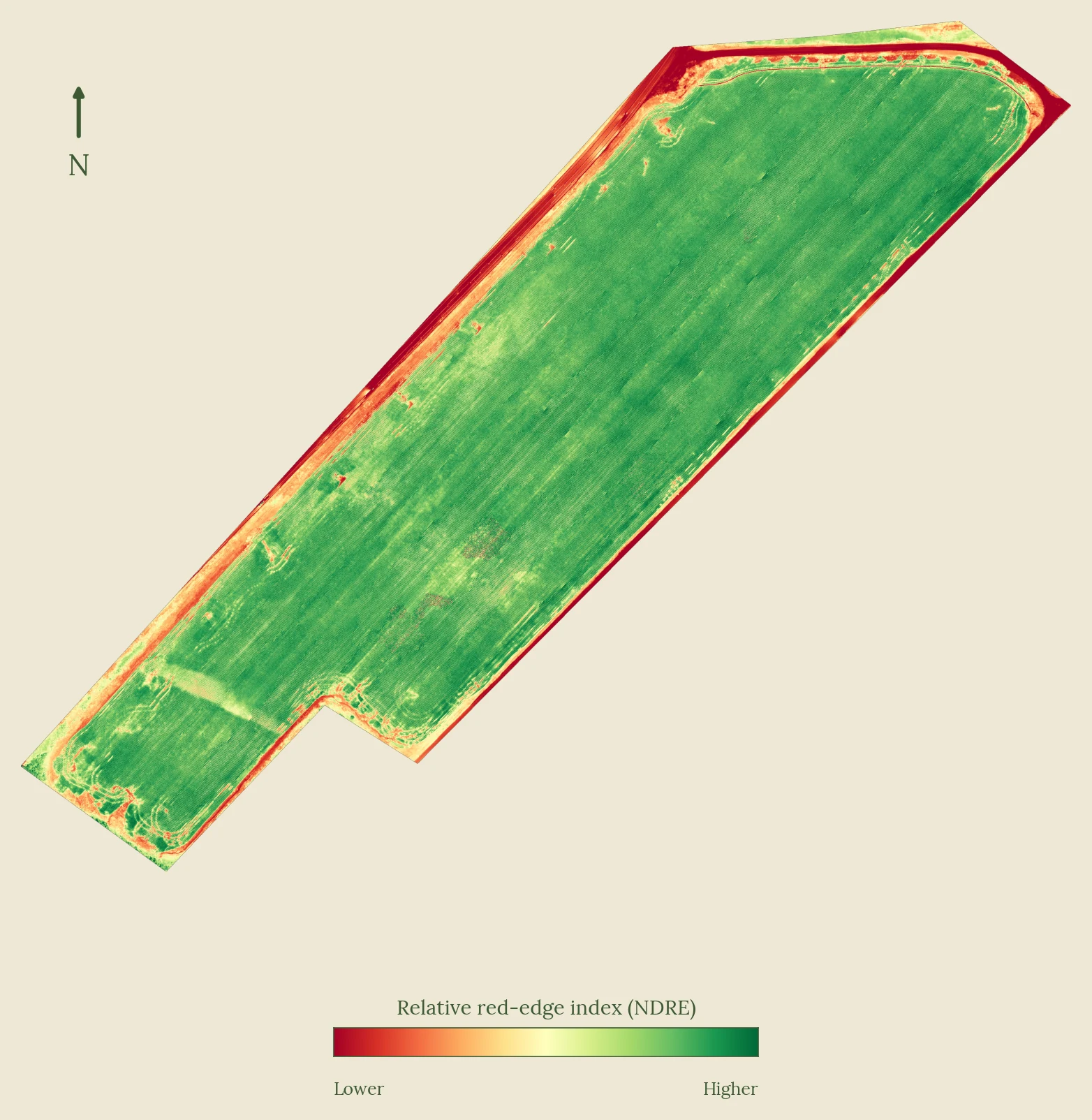
Aerial Crop Scouting for Mid-South Consultants

You can't walk every field the week it matters. We can fly them.

Delta Map and Drone is the aerial scouting arm for independent crop consultants across the Mid-South. You read the data and write the prescriptions. We capture NDVI and orthomosaics on your client fields and put finished maps in your hands within 48 hours. One relationship covers your whole book. We do not sell chemicals, hardware, or prescriptions, so we are never competing for your growers.

Let's talk through your book →

First Field Free

Pick one problem field off any of your clients' operations. We fly it, process it, and hand you the maps at no cost, so you can see the data quality before you put us in front of a grower.

What you get

A within-field NDVI map, false-color imagery, RGB orthomosaic, and a written field summary, back within 48 hours of the flight. The files are yours whether or not anything comes of it.

What it costs

Nothing. No mobilization fee, no processing fee, no obligation. If the data earns a place in your scouting, we talk about covering more of your book. If not, you keep the files and we move on.

The catch

Limited to ten demonstrations for the 2026 season, on a first-come basis. The program closes July 31, 2026, or once all ten are booked, whichever comes first. Reserved for independent consultants managing 1,500 or more aggregate acres, and for farms qualifying for a Standard or Large-Scale retainer.

Reserve a First Field Free slot →

Full eligibility and terms

Acreage cap. A single known problem field, maximum 100 acres. Larger fields receive the first 100 acres free; the remainder is billed at the standard per-acre rate.

Geographic boundary. Within the standard 90-minute operational radius of Memphis, Tennessee. Covers most counties across the Mid-South.

For consultants and qualifying farms. Reserved for independent crop consultants managing 1,500 or more aggregate acres, or farms qualifying for a Standard or Large-Scale seasonal retainer. Hobby plots and homesteads are referred to the Small-Plot Pickup Package.

Deliverable scope. A within-field NDVI map, viewable orthomosaic, prescription-ready exports for the demonstrated field, and field summary report. Multi-flight time series, mid-season reflights, and end-of-season field performance review are retainer-only benefits, released only on conversion to a paid retainer.

Program limits. Maximum 10 demonstrations for the 2026 season, on a first-come basis. Program closes July 31, 2026, or once all ten are booked, whichever comes first.

Built around your operation, not your grower's

We are the imaging arm, not another advisor. You stay the agronomist of record. We fly, we process, we hand you the files, and we stay out of the way of the relationship you have already built.

One relationship, your whole book

Fly any field, any client, on your schedule. You are not re-explaining the service every time you add a grower.

Plugs into your prescriptions

Prescription-ready exports in standard formats for FieldView, Granular, and Ag Leader. The recommendation that reaches the grower is yours, not ours.

No conflict, by design

We sell no chemicals, no hardware, no prescriptions. Nothing to upsell your grower, no reason to second-guess your call. Just honest within-field imagery, flight after flight.

Per-client coverage

We issue a certificate of insurance naming each grower for the fields we fly, so the paperwork is clean on every operation you bring us.

Coverage you can't scale on foot

Full-field NDVI on every acre flown shows you where to put your boots, so you spot-check the fields that need you instead of windshield-scouting blind.

Why it works for Delta row crops

The imaging season runs May through September. Peak demand is July and August, when stress that hasn't shown up visually is already costing yield.

Crop Critical Scouting Window Best NDVI Flight Window What You're Catching
Soybeans July – August June – September Flowering stress, sudden death, iron deficiency chlorosis
Cotton July – August July – September Boll development stress, root rot, potassium deficiency
Corn June – July May – August Pollination failure, gray leaf spot, nitrogen deficiency
Rice (AR Delta) July – August June – September Heading stage stress, straighthead, blast pressure

An honest map you can scout on

Within-field NDVI shows where the stress is on each flight, healthy acres against struggling ones, which is what drives a scouting pass. We do not claim lab-grade cross-date reflectance we cannot stand behind. You get a map you can trust to send a scout on.

Targets inputs where they pay

Variable-rate application informed by NDVI directs inputs toward stressed acres instead of spreading them evenly. On a large operation, even a modest per-acre saving offsets much of the cost, which is an easy case to make to your grower.

Documentation for your grower's claim file

Georeferenced, timestamped imagery from across the season is useful supporting evidence for a claim file, the kind of record an adjuster values. A field summary and orthomosaic from July beats a memory of what things looked like, though it isn't a formal insurance instrument on its own.

What lands in your inbox after every flight

Every flight comes back as a finished package within 48 hours of landing, backed by a hard 72-hour guarantee. No platform to log into, no subscription, no raw data to wrestle with, and your imagery never leaves our hands for someone else's cloud. You get plain maps and a plain-language summary that tell you which fields to walk and where to look first.

NDVI Vegetation Index Map

Color-coded map showing relative crop-vigor variation across every acre flown, with apparent stress zones highlighted and georeferenced for ground-truthing.

Written Field Summary

Plain-language summary with flagged stress zones and location references, a targeted scouting roadmap for your own pass or your field scouts, and a record for your grower's claim file.

Prescription Map Export

Optional variable-rate application map exportable in standard formats for common variable-rate platforms including FieldView, Granular, and Ag Leader. So stressed acres get the input, healthy acres don't.

False-Color Health Imagery

Multispectral composite that can surface canopy stress earlier than the naked eye or standard RGB photography typically show.

RGB Orthomosaic

High-resolution stitched aerial image of the entire field, usable for field records, landlord reporting, and your grower's claim file.

Season-Long Time Series

Multiple flights across the season build a date-stamped, georeferenced visual record showing where and when field conditions changed, useful documentation for crop insurance and next-year planning.

Seasonal Crop Health Monitoring

Fixed-price retainers for the growing season, covering fields across your book. You know the cost up front, flights are scheduled around the crop calendar, and you're not paying for a flight you don't need.

Large-Scale
1,501–3,000 acres
4 flights / season
$14,500
per season

Who's flying

FAA Part 107 Certified

FAA Part 107 is required for commercial drone operations. It covers airspace regulations, weather, crew resource management, and radio communications. Not everyone flying a drone has it.

Fully Insured

$1M aviation liability coverage, active before the first paid flight. Certificate of insurance available on request, naming the grower for the fields we fly.

Delta-Based, Delta-Focused

Active pilot projects underway on 5,500 acres of working row-crop ground, a 4,000-acre Arkansas operation and a 1,500-acre Mississippi operation.

Processes Data In-House

Photogrammetric processing runs on self-hosted infrastructure using WebODM, not a cloud subscription that adds cost and introduces a third party to your client's field data. Their imagery stays where it belongs.

Now Booking 2026 Flight Slots

Mid-season and late-season flight slots for the 2026 growing calendar are open and filling. If you are an independent consultant working fields across the Mid-South, reach out to talk through your book and the fields you can't get to in the weeks that matter, and reserve your dates before the peak July–August window closes.

No pitch call. Just a conversation about who you cover, what you're seeing this season, and whether this fits how you scout. First Field Free demonstrations are available for qualifying consultants. Mention it in your message.